Republican Period
Archeology and written sources seem to confirm the traditional idea that the Roman Corduba was founded in the mid second century BC by General Marcus Claudius Marcellus, after a long period of coexistence among colonists and troops with the old indigenous settlement located on Colina de los Quemados (current Parque Cruz Conde).

The new Corduba chose for its location a natural terrace easily defendable. Placed about 750 meters northeast of the Turdetan nucleus, and separated both by several waterways that flowed into the future river Baetis, this new settlement gradually polarised the population of the area, which finally caused the abandonment of the old Turdetan oppidum.

The new city, which mints its first coins with the legend Corduba around about the years 80-79 BC, rapidly prospered thanks to trading, to the agricultural valley resources, to the control of the river port, as the river was navigable to its very gates, and especially to the mining wealth of its mountain, which funds the conquest and favors the enrichment of the first cordubenses family lines.
It is not possible to determine in which moment the first bridge is made, very probably of perishable materials, but there are enough arguments to think that it coincided approximately with the new foundation.

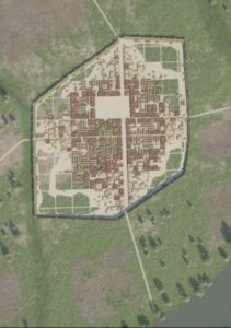
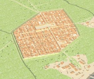
At the beginning, the Republican city occupied only the top of the hill that still forms the center of the modern city. It is an essentially flat surface, protected by pronounced slopes except on its northern side (where a defensive moat of great width and depth was disposed), and by the channels of several streams. Its planning follows the characteristics of Italic urbanism, with a walled perimeter provided with towers and a regular urban road network governed by the kardo and decumanus maximums, oriented to the four cardinal points, and organized in blocks (insulae) of 2 by 2 actus (that is to say, 70 x 70 meters). As a singular element, the new Corduba had two decumani maximi, one of which was the entrance to the walled enclosure in the East, and another was the way out towards the West. This solution was probably aiming to reinforce the iconic character of the space reserved for the forum. The first formal paving of streets, the installation of an effective sewers network and the first monumentalization of houses and public buildings have not been archaeologically detected until the early first century BC. Until then the city would have maintained a certain camp aspect, with buildings mainly built in stone, wood and mud.

The building of this first wall should have begun around the mid second century AC., by passing a total area of approximately 47 hectares. It was composed by a thicker outer wall of around 2 and 3 meters wide, made of large calcarenite blocks and provided with semi-circular towers (completed, later on, with some other rectangular); an agger or compact slope made of river stones, masonry and clay, around 6 meters wide, and a containment wall below, between 0.60 and 1.20 meters wide. On its western side, this wall followed an almost rectilinear path, which fitted the river course of the Arroyo del Moro, used as a moat. It also suited the topography, which goes sloping gently towards the Southwest. As we said before, on its western and northern sides, more vulnerable, an artificial moat of 15 meters wide and 4 deep was built. The eastern front ran along the middle of the hillside, defining this side of the town. Finally, the southern section of the wall is less well known, as it was dismantled after the enlargement of the city towards the river.

Since its origins, Corduba had a civic and monumental center, which was a reference place for its inhabitants from a religious, political, legal and administrative point of view. This was the Forum of the Colony, located around the confluence of the current Góngora and Cruz Conde streets, and about 4 meters deep in relation to the current floor elevation. Although its last appearance remains unknown, several digs and data point to the idea of a long and arcaded square paved with clay. Its existence, as well as the role of Corduba as the provincial headquarters of the Praetor -as justice was dispensed from here at the same time that government issues were solved-, is documented by written sources since at least 113/112 BC. (Cicero, In Verr., 2, 4, 56). Overall, its location coincides with the subsequent Forum of Augustus, although this was smaller and was crossed, on its eastern side, by the Kardo Maximum, following the open or integrated forum model that was typical then. It would have been presided by a main temple that would have hosted, perhaps, several fluted shaft columns, carved in local stone, reused years after in the southern wall. Written sources confirm the existence of a basilica at least since the mid first century BC. Finally, there was possibly an early access to the forum from the North through a triumphal arch, dominated by a representation of Victoria.
Overall, we have scarce information about places of worship in the Republican Corduba. Under the Casa Carbonell, the remains of columns of almost one meter in diameter and Doric-Tuscan capitals were excavated years ago, interpreted as belonging to a possible temple. If so, it must have been surrounded by a portico that would have ennobled the kardo maximus in access to the city from the South. Its chronology would fluctuate between the late second and early first century BC.
Regarding housing, the oldest known remains refer to mid or late second century BC. They were built on a foundation made of boulders, with elevations of adobe and /or mud, dirt or gravel floors and vegetal roofs, according to the indigenous habits. Inside, the decoration in walls was limited to flat colours, especially red and black. At the beginning of the first century BC, walls made of masonry, roofs made of tegulae, opus signinum pavements with white limestone or quartzite tesseras, and more colourful wall paintings start to become common. In these early days there were still no aqueducts to bring running water, so the water supply came from wells and cisterns.
We do not have much information related to the funerary rites at this time, maybe because the first cemetery spaces were buried under the city expansion towards the south in the Augustan period. This can be intuited through some archaeological finds, such as the possible funerary monument of Murria, dismantled before the construction of the theater (15 B.C.-5 A.D.) and recovered under the foundation of its cavea; or the ionic shafts with stucco found in the area of the Alcázar de los Reyes Cristianos, which could have belonged to a late republican edicola. So far, the oldest monumental traces recorded are the rectangular enclosures from the first half of the 1st century A.C. detected under the burial mounds of Puerta de Gallegos. All these cases were located very close to the city gates, along the most important communication ways. The scarce data known until now refer to Italic influences attributable to the first colonists.

In the mid first century BC, the civil wars between Caesar and Pompey’s sons, that would end the Roman Republic, arrived to cordobesian lands. Corduba took sides for the Pompeian side, and therefore it was besieged and destroyed by the troops of Caesar and 22,000 of its inhabitants were put to the sword. After that, the city experienced a period of crisis that would last a few decades, until some political manoeuvres managed to gain the favor of the new Princeps, Octavius Augustus. Assigning lots of lands, he managed to install in Corduba a great number of veterans from the wars in the North, meanwhile he raised the legal status of the city to colonia, and added the Patricia patronymic.
Bibliography
CARRILLO DÍAZ-PINES, J. R . et alii (1999): “Córdoba. De los orígenes a la Antigüedad Tardía, en F. García Verdugo y F. Acosta (eds.), Córdoba en la Historia, la construcción de la Urbe, Córdoba, pp. 37-74.LUZÓN, J.M. y RUIZ, D. (1973): Las raíces de Córdoba. Estratigrafía de la Colina de los Quemados. Córdoba.
LUZÓN, J.M. y RUIZ, D. (1973): Las raíces de Córdoba. Estratigrafía de la Colina de los Quemados. Córdoba.
MARCOS POUS, A. (1976-1978): “Aportaciones a la localización y conocimiento de la Corduba prerromana”, Ampurias: revista de arqueología, prehistoria y etnografía, nº. 38-40, pp. 415-422.
MURILLO, J. F. (1994): “Corduba: de la ciudad indígena a la ciudad romana”, La ciudad en el mundo romano. Actas del XIV Congreso Internacional de Arqueología Clásica. Vol. 2. Comunicaciones, Tarragona, pp. 260-261. Tarragona.
MURILLO REDONDO, J. F. (1995): “Nuevos trabajos arqueológicos en la Colina de los Quemados: el sector del teatro de la Axerquía. Parque Cruz Conde, Córdoba”,AAA 1992, III, pp.188-199.
MURILLO, J. F. y VAQUERIZO, D. (1996): “Corduba prerromana” en LEÓN, P. (ed.): Colonia Patricia Corduba, una reflexión arqueológica, Córdoba, pp. 37-47.
MURILLO REDONDO, J. F., JIMÉNEZ SALVADOR, J. L. (2002): “La fundación de Córdoba”, en J. L. Jiménez y A. Ribera (eds.) Valencia y las primeras ciudades romanas de Hispania, Valencia, pp. 183-193.
RUIZ LARA, Mª.D.; MURILLO REDONDO, J.F (1992): “Aproximación al Bronce Antiguo y Pleno en el sureste de la Campiña cordobesa”, AAC, nº3, pp. 9-36.
VAQUERIZO GIL, D. (2003): Guía Arqueológica de Córdoba, Córdoba.
VAQUERIZO GIL, D. et alii (2011): “Novedades de arqueología en Corduba, Colonia Patricia”, en Colonias de César y Augusto en la Andalucía romana, Roma, pp. 9-46.
VAQUERIZO GIL, D. y RUIZ BUENO, M. D. (2014): “Últimas investigaciones arqueológicas en Corduba, Colonia Patricia, una propuesta de síntesis” en MARTÍN BUENO, M.; SÁENZ PRECIADO, C. (coords.): Modelos edilicios y prototipos en la monumentalización de las ciudades de Hispania. Zaragoza, pp. 15-32.
VENTURA VILLANUEVA, A. (2011): “Caracterización de la Córdoba romana, de sus fundaciones, fundadores y funciones”, en Baena, M.D., Márquez, C., y Vaquerizo, D. (Eds), Córdoba. Reflejo de Roma, Córdoba, 2012, pp. 30-42.

